|
|
Inishowen to welcome elite
cyclists for An Post Rás
19.05.17
THE An Post Rás gets
underway on Sunday with three stages of the elite
cycling race taking place next week in Donegal
including Inishowen's gruelling Mamore Gap.
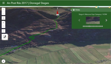
To mark the race's return to the county after five
years, Donegal County Council’s GIS team has
produced a nifty interactive map that can be used by
cyclists, spectators and those following the route.
“The main map highlights the routes for stages 4, 5,
and 6 on Wednesday, Thursday and Friday next," said
the council's GIS project leader Daragh McDonough.
“The map also includes distance markers, estimated
arrival times at various locations along each stage
and includes the locations of all the mountain
climbs." |
Daragh believes that
this map will be useful to safely plan spectating or
following the peloton through the county.
“You can get a real virtual feeling of the route
using the 3D map with bookmarks to key locations
along the route showing the length and severity of
climbs. And we would encourage spectators to upload
their images onto our social photo map”.
An Post Rás is an annual, eight-day, stage race
around Ireland and is taking place from May 21 - 28,
2017. The epic race began in 1953 and has been held
every year since. It is one of Ireland’s top
sporting events bringing world class sporting action
and a significant economic boost to towns and
villages nationwide.
This map can be found at DonegalCoCo.ie or for the
direct link to map
Click Here . |
|
|
|