|
|
Inishowen half-cut as map wipes us
out
09.02.12
by Linda McGrory
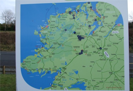
INISHOWEN is "half cut" according to an official
tourism sign that wipes a large portion of the
peninsula off the map.
The sign, located at a picnic lay-by on the main
Letterkenny to Inishowen road at Manorcunningham
makes it appear like the peninsula ends in an arc
from Clonmany to Redcastle. Towns including
Carndonagh, Malin, Culdaff, Moville and Greencastle
are axed while Ireland's most northerly point, Malin
Head, is nowhere to be seen.
Donegal County Council yesterday stressed that the
contentious sign was top of the list to be replaced
this year with one of the new Inishowen 100
interpretative signs.
However, in the meantime, the Manor map makes it
seem like Fanad is the country's most northerly
point while it does not list a single attraction in
the peninsula to visit.
Fianna Fáil councillor, Paul Canning, yesterday
described the sign as "an insult".
"Malin Head has been Ireland's most northerly point
since the day dot and unless there has been some
serious coastal erosion in the last while, it's
still Ireland's most northerly point, yet it's
nowhere to be seen on this map. |
 |
|
Tourism sign in Manorcunningham, on
the main Letterkenny to Inishowen road. |
"Down in Cork, you can
be sure they are at pains to highlight their most
southerly point. This demonstrates a serious lack of
knowledge."
Cllr Canning said the existing map, in situ for some
years, is insulting especially to ratepayers running
businesses in the north and north east of Inishowen.
He said the map further disadvantages the peninsula
because among the 21 attractions listed not one is
in Inishowen.
"This map is located on the road going directly to
Inishowen but half of the peninsula is not included
on it and not one Inishowen tourism attraction is
listed."
It is understood the Manor sign was part of a set of
linking signs created some years ago to market West
Donegal; Limavady and the Roe Valley; Letterkenny
and North Donegal and Inishowen. At the time,
Manorcunningham was not part of the Inishowen
electoral area.
Donegal County Council's tourism development
officer, Kevin O'Connor, yesterday said he could not
comment specifically on an old EU sign going back
quite some years.
However, he stressed that a lot of money was being
invested in Inishowen this year and in the coming
years.
"We have secured €181,000 in funding to tackle all
the existing signage and revamp the Inishowen 100 in
conjunction with Failte Ireland and Inishowen
Tourism. We have done an audit of all the signs and
we will be replacing the (Manor) sign plus revamping
all the brown tourism signage on the Inishowen 100."
Meanwhile, Mr O'Connor said people in Inishowen
could look forward to a number of major tourism
developments this year. He said €220,000 had been
secured from the EU-Interreg programme and the
Loughs Agency for Malin Head including an upgrade of
the coastal path, better road access and
interpretative signage. Meanwhile, EU-Interreg
funding had been approved for the final phase of the
Inch Level project bringing the total value of the
completed project to some €800,000. The final phase
will include additional car parking, the completion
of the Inch Lake loop walk and a full interpretative
plan for the wildlife sanctuary. |
|