It also allows users to
turn on and off different map layers and provides
links to weather cameras to view live conditions. It
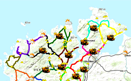
also shows the locations of public sand and grit and
provides details of the winter maintenance service
routes. The local authority has included an hourly
forecast feed for most areas in the county so that
the users can check their local forecast for the
next 12-24 hours.
Daragh McDonough, GIS Manager with Donegal County
Council said: "We have been working with our
colleagues in our Roads Service to make sure that
road users can access as much relevant information
as they need to make safe driving decisions during
the winter months”.
With the weather set to get colder of over the
weekend, Mayor of Donegal Cllr Ian McGarvey
encouraged the public check out the new interactive
map. It is available at
www.donegalcoco.ie . |